River Discharge Model
According to Centre for Research on the Epidemiology of Disasters (CRED), floods were the most frequent natural disasters occurring worldwide from 2000 to 2019. The frequency of floods is also increasing, rising from 71 events per year on average between 1980 and 1999 to an annual average of 171 events in the period between 2000-2019. Our aim is to develop a riverine flood forecasting model that scales to different regions with no manual calibration.
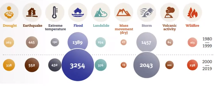
Fig.1: Total disaster events by type: 1980-1999 vs 2000-2019 (Source: CRED)
The model uses a data driven approach to forecast river discharge. River discharge is the amount of water that flows through a river section at a given time. We combine our predicted river discharge values with flood threshold (the capacity of a river to cause flooding) to calculate the total extent of flooding. A single Long Short-Term Memory Network (LSTM) is trained using past values of discharge, meteorological time series data and static attributes.
Kratzert et al. shows a single universal deep learning model can learn both regionally-consistent and location-specific hydrologic behaviors. Kratzert et al. benchmarked the LSTM model with classical hydrology models.
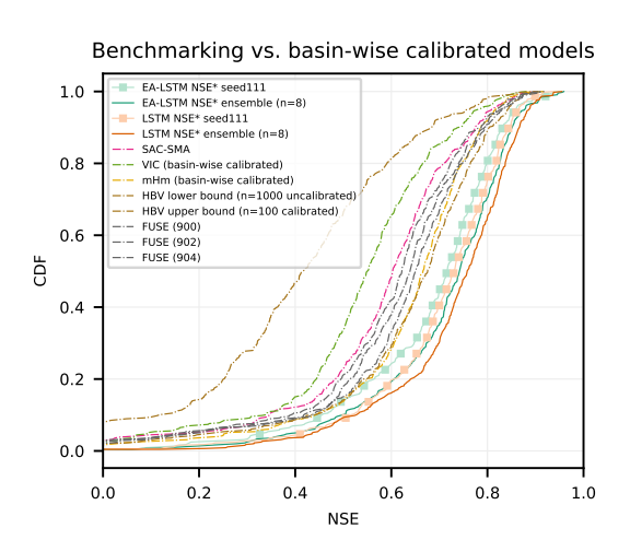
Fig.2: The distribution of Nash–Sutcliffe model efficiency coefficient (NSE) is used to assess the predictive skill of hydrological models. (Source: Kratzert et al.)
Data
The Copernicus Climate Data Store (CDS) API is used to scrape the following datasets:
GloFAS Daily river discharge (cubic meters per second).
ERA5-Land hourly 2 meter temperature data (kelvin).
Upstream area (square meters).
To use the Copernicus Climate Data Store (CDS) API, user id and key are required to be added to the .env file.
Therefore, first create an CDS account here and
visit this page to get the user id and the key.
The Climate Hazards group Infrared Precipitation with Stations (CHIRPS) is the source of the daily rainfall data.
It is scraped from https://data.chc.ucsb.edu/products/CHIRPS-2.0/africa_daily/tifs/p05/.
The source of the digital elevation model (DEM) is HydroSHEDS.
Data preprocessing
The script data_pre scrapes, resamples and compiles data from various sources into an xarray dataset that is used to train the model. Data preprocessing steps include:
Scraping river discharge from Copernicus Climate Data Store
Scraping upstream area from Copernicus Climate Data Store
Scraping temperature data from Copernicus Climate Data Store
Scraping rainfall data from Climate Hazards group Infrared Precipitation with Stations (CHIRPS)
Hourly two meter temperature data is aggregated to get daily data.
Rainfall and digital elevation data is resampled to match the spatial resolution of the river discharge.
Before training the model, the data is normalized to a mean of 0 and a standard deviation of 1.
The data used for inference is pre-processed and saved in CKAN as a netcdf file. The temporal coverage of pre-processed data is from Jan 2017 to Dec 2018 for both South Sudan and Ethiopia.
Building the model
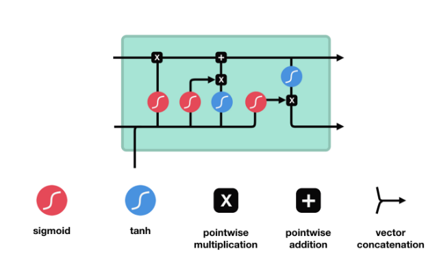
Fig.3: The Long Short-Term Memory networks (LSTM) model architecture
The Long Short-Term Memory networks (LSTM) model is trained with the meteorological time series data and static location specific attributes. The length of the input sequence is 60 days.
LSTM is a type of neural network architecture that is optimized for time series prediction that requires long memory. The key to LSTMs is the cell state and various gates. Cell state carries relevant information throughout the processing of the sequence. The information gets added or removed to the cell state via gates. During training the gates learn which information is relevant to keep or forget.
where: \(f_{t}\) is the forget gate, \(i_{t}\) is the input gate, \(g_{t}\) is the cell input, \(C_{t}\) is the cell state, \(C_{t-1}\) is the previous cell state, \(o_{t}\) is the output gate, \(h_{t}\) is the hidden state, \(h_{t-1}\) is the previous hidden state, and \(x_{t}\) is the input.
Model output
The model forecasts river discharge and estimates riverine flooding at daily time steps.
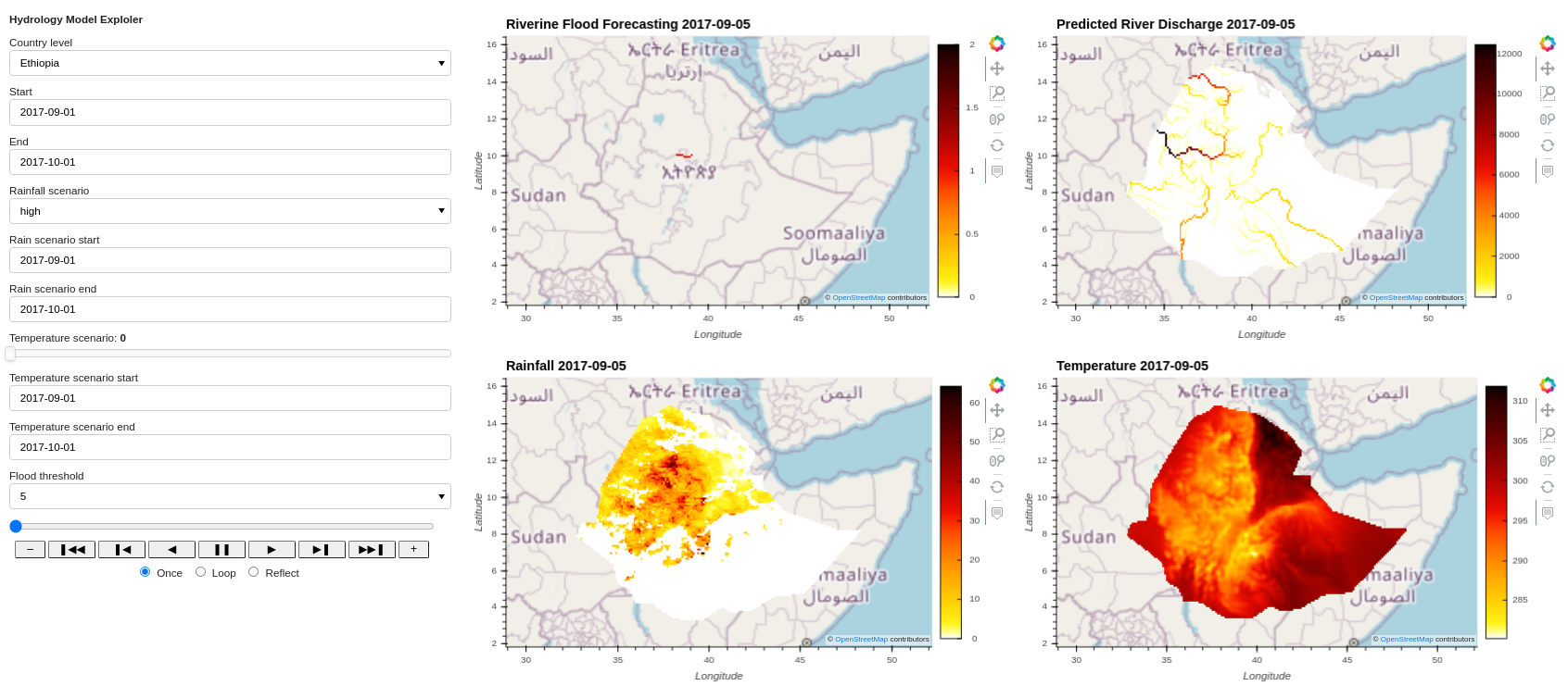
Fig.4: Hydrology Model Exploler
Quickstart code
River Discharge
The model forecasts river discharge at daily time steps in both South Sudan and Ethiopia. The model outputs are available in NetCDF and parquet format.
River discharge tunable parameters include:
country_leveldescription: Set the spatial extent of outputs to a country.
metadata:
type: ChoiceParameter
default: “South Sudan”
geographydescription: Spatial extent of outputs, as a GeoJSON object.
metadata:
type: GeoParameter
default: GeoParameter(default=Polygon(coordinates=[[(23, 12.5), (23, 2), (36, 2), (36, 12.5), (23, 12.5)]]))
timedescription: Temporal extent of outputs as a date range (excluding the end date).
metadata:
type: TimeParameter
default: 2017-01-01-2017-06-01
rainfall_scenariodescription: Use current rainfall data or use a scenario based on deviations from daily long term mean.
metadata:
type: ChoiceParameter
default: normal
rainfall_scenario_timedescription: The time period for the rainfall scenario
metadata:
type: TimeParameter
default: 2017-05-01-2017-05-02
rainfall_scenario_geographydescription: Spatial extent of rainfall scenario
metadata:
type: GeoParameter
default: GeoParameter(default=Polygon(coordinates=[[(23, 12.5), (23, 2), (36, 2), (36, 12.5), (23, 12.5)]]))
Below are examples of commands that predict river discharge in Ethiopia for the time period 2017-01-01 to 2017-02-03:
Netcdf output format command:
luigi --module models.hydrology_model.river_discharge.tasks models.hydrology_model.river_discharge.tasks.PredictRiverDisharge\
 --local-scheduler --country-level Ethiopia --time 2017-01-01-2017-02-03
Parquet output format command:
luigi --module models.hydrology_model.river_discharge.tasks models.hydrology_model.river_discharge.tasks.RiverDischargeToParquet \
--local-scheduler --country-level Ethiopia --time 2017-01-01-2017-02-03
Riverine Flooding
The model also estimates the riverine flooding. If the predicted river discharge exceed flood threshold and the basin is greater than 5,000 km2, the pixel is classified as flooded. The role of flood defences is not considered.
Riverine Flooding tunable parameters include:
country_leveldescription: Set the spatial extent of outputs to a country.
metadata:
type: ChoiceParameter
default: “South Sudan”
geographydescription: Spatial extent of outputs, as a GeoJSON object.
metadata:
type: GeoParameter
default: GeoParameter(default=Polygon(coordinates=[[(23, 12.5), (23, 2), (36, 2), (36, 12.5), (23, 12.5)]]))
timedescription: Temporal extent, of outputs as a date range (excluding the end date).
metadata:
type: TimeParameter
default: 2017-01-01-2017-06-01
rainfall_scenariodescription: Use current rainfall data or use a scenario based on deviations from daily long term mean.
metadata:
type: ChoiceParameter
default: normal
rainfall_scenario_timedescription: The time period for the rainfall scenario
metadata:
type: TimeParameter
default: 2017-05-01-2017-05-02
rainfall_scenario_geographydescription: Spatial extent of rainfall scenario
metadata:
type: GeoParameter
default: GeoParameter(default=Polygon(coordinates=[[(23, 12.5), (23, 2), (36, 2), (36, 12.5), (23, 12.5)]]))
return_period_thresholddescription: The return period discharge magnitudes used as flood thresholds.
metadata:
type: IntParameter
default: 10
Below are examples of commands that estimate riverine flood extent in Ethiopia for the time period 2017-08-01 to 2017-10-01:
Netcdf output format command:
luigi --module models.hydrology_model.river_discharge.tasks models.hydrology_model.river_discharge.tasks.RiverFlooding \
--local-scheduler --country-level Ethiopia --time 2017-08-01-2017-10-01
Parquet output format command:
luigi --module models.hydrology_model.river_discharge.tasks models.hydrology_model.river_discharge.tasks.RiverFloodingToParquet \
--local-scheduler --country-level Ethiopia --time 2017-08-01-2017-10-01
Constraints
The LSTM model for predicting river discharge runs in sequence-to-value mode. The discharge values in the sequence are the observed values, not predicted values.